![]()
![]()
As terrestrial inhabitants of planet Earth, we have developed our understanding of chemistry nearly exclusively from very near its liquid and solid surfaces. But since the middle of the 20th Century, humans have begun to develop technology for investigating our planet from orbiting platforms. What (will) follow below gives a brief overview of that technology. The following investigations discusses how this has been extended to investigating the chemistry of the neighboring planets in our solar system, and more recently to the discovery and investigation of planets beyond our solar system.
If you wanted to access the health of another person, you might place your inside wrist on their forehead or use a thermometer. A physician might shine a light into their throat and evaluate the color reflected back to her eyes. Similar methods might be used from greater distance to evaluate the health of a planet such as the Earth. With lessor or greater amounts of instrumentation, it is possible to learn about a planet from the various kinds or radiation emitted by the planet. Or with more difficulty, radiation might be reflected from the planet and variations in the returning radiation evaluated.
 The first Sputnik (Спутник =
 traveling companion
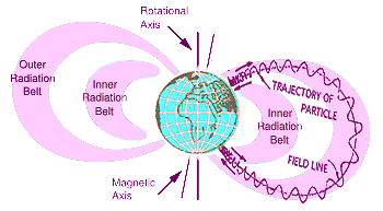
), launched on 4 October, 1957, by the Soviet Union, carried two radio transmitters which provided for tracking its orbit. After repeated failure of the United States Navy Vanguard satellite efforts, the United States Army used a stock missile to orbit the lighter Explorer 1 built by James Van Allen and his team at the University of Iowa. Launched on 31 January, 1958, Explorer 1 carried a Geiger counter to investigate the cosmic rays along the moderately eccentric orbit. The radiation reported by this and later Explorers provided a way to map the Earth's magnetic fields. Charged particles detected by the Geiger counter, such as electrons, protons, and ionized atoms, are deflected when they cross the magnetic field. If they intersect field lines other than perpendicular, they will spiral around the field lines, reflected as the field lines become concentrated near the Earth's poles. Discovery by the Explorer satellites of layered regions of such captured particles led to their being named the Van Allen belts. The inner belt contains mostly protons which encounter the atmosphere near the poles, causing the atmosphere to fluoresce, creating the colorful borealis. The resulting loss of energy leaves the charge particles captured and remaining for a long time, bouncing back and forth from one hemisphere to the other. Further out is a large region, the outer radiation belt, containing ions and electrons of much lower energy. Unlike the inner belt, the radiation intensity fluctuates widely, rising when magnetic storms on the Sun inject fresh particles, then gradually decreasing as particles escape.
Most of the remote satellite sensors are strictly passive, analyzing electromagnetic radiation reaching the location of the satellite by normal processes. The satellite either captures an image in the form of a photograph, or filters and scans the incoming light waves. By selective determining which light to analyze and when it is detected, a great variety of information can be determined about the Earth.
One set of satellites orbits the Earth's equator at very high altitude so that one orbit takes 24 hours, exactly matching the rotation of the earth below so that the satellite remains fixed above a specified site on the Earth's Equator. The geosynchronous orbit is about 35,800 km (22,300 miles) above the Earth, high enough to allow the satellites a full-disc view of the Earth. Because each satellite stays above a fixed spot on the surface, they provide a constant vigil for the atmospheric "triggers" for severe weather conditions such as tornadoes, flash floods, hail storms, and hurricanes. The POES system includes the Advanced Very High Resolution Radiometer (AVHRR described below) and the Tiros Operational Vertical Sounder (TOVS) Geosynchronous orbiting satellite images are also used to estimate rainfall during the thunderstorms and hurricanes for flash flood warnings, as well as estimates snowfall accumulations and overall extent of snow cover.
 The Sounder (diagram at right→) has 4 sets of detectors (visible, long wave infrared, medium wave infrared, short wave infrared). The incoming radiation passes through a set of filters before reaching the detectors. The filters are mounted on a rotating (28.2 cm) wheel containing 18 filter windows, divided into 3 concentric rings, one for each IR detector group. The outer ring contains 7 long wave filters, the middle ring 6 short wave filters, and the inner ring 5 medium wave channels. The visible wave lengths do not pass through a filter. The mirror scanning sequence takes places by sweeping in an East-West direction, stepping in the North-South direction, than sweeping back in a West-East direction, stepping North-South, then repeating.
Another set of satellites orbits over the earth's poles while the Earth rotates daily underneath. This allows the satellites to collect global data on a twice daily basis over every earth location. Data from such polar orbiting satellites supports a broad range of environmental monitoring applications including weather analysis and forecasting, climate research and prediction, global sea surface temperature measurements, atmospheric soundings of temperature and humidity, ocean dynamics research, volcanic eruption monitoring, forest fire detection, global vegetation analysis, search and rescue, and many other applications. A suite of instruments is able to measure many parameters of the Earth's atmosphere, its surface, cloud cover, incoming solar protons, positive ions, electron-flux density, and the energy spectrum at the satellite altitude. The polar orbiters' ultraviolet sensors also provide ozone levels in the atmosphere and are able to detect the ozone hole over Antarctica during mid-September to mid-November. Ozone is an effective absorber of UV energy. Without Ozone, UV is transmitted directly to the Earth's surface, which can cause severe health problems for people and other forms of life on Earth. Carbon dioxide in the Earth's lower atmosphere absorbs radiation at wavelengths between 13 μm and 17.5 μm. Water Vapor, also in the Earth's lower atmosphere, absorbs solar radiation in wavelength regions near 1.1 μm , 1.4 μm , 1.9 μm, 5.5 μm , 7 μm , and above 27 μm.
One sensor (called AVHRR) is an picture forming imager of detected electromagnetic waves which can be used for remotely determining cloud cover and the surface temperature with a resolution of about 1 km. The surface might be the solid surface of land, but depending on wavelength, the closest reflecting surface could be the upper surfaces of clouds, or the surface of a body of water. The scanning radiometer uses 6 detectors that collect different bands of radiation wavelengths as shown below. Measuring the same view, this array allows multi spectral analysis. Comparing data from two channels is often used. The three channels operating entirely within the infrared band are used to detect the heat radiation to obtain the temperature of land, water, sea surfaces, and the clouds above them.
| Wavelength (μm) | Typical Use |
| 0.58 - 0.68 | Daytime cloud and surface mapping |
| 0.725 - 1.00 | Land-water boundaries |
| 1.58 - 1.64 | Snow and ice detection |
| 3.55 - 3.93 | Night cloud mapping, sea surface temperature |
| 10.30 - 11.30 | Night cloud mapping, sea surface temperature |
| 11.50 - 12.50 | Sea surface temperature |
All objects on the Earth's surface must interact with electromagnetic waves by reflecting, absorbing, or transmitting the radiation. Different objects have fingerprint reflectance and absorption signatures that enable interpretation of the sensor outputs (for example, an oak tree reflects electromagnetic radiation differently than a pine tree). In addition, different parts of the electromagnetic spectrum are best suited for different tasks. A satellite with high enough resolution can produce images which can provide useful information. The value of such remote sensing became apparent during World War II when it was noted that aerial photographs using film sensitive to the near infrared would clearly show any areas that the enemy had camouflaged. Cut branches or green and brown webbing were often used to hide planes, tanks, and other military equipment. The camouflage fooled the naked eye because in the visible spectrum, it looked like trees and grass, but photographs using near infrared showed live vegetation clearly different from dead vegetation or rope and painted canvas.
Today remote sensing provided by Landsat satellite images has a broad range of applications. But unlike the broad images of large patches with the entire Earth being frequently studied, the Landsat program records only a few small sections of the Earth each day. But the detail such as displayed by Google satellite images provides the value. Imaging radar (where radio signals generated by the satellite are reflected back) has been used to locate ancient river beds and lakes, and lost archeological sites. Radar and optical remote sensing are used in oil and mineral exploration, and in determining wetland loss and urban growth. The table below shows some specific uses of different parts of the electromagnetic spectra (visible and infrared).
| Agriculture, Forestry, and Range Resources | Land Use and Mapping | Geology | Water Resources | Coastal Resources | Environment |
| Discrimination of vegetative, crop, and timber types, and range vegetation | Classification of land uses | Mapping of major geologic units | Determination of water boundaries and surface water areas | Determination of turbidity patterns and circulation | Monitoring environmental effects of man's activities (lake eutrophication, defoliation, etc.) |
| Measurement of crop and timber acreage | Cartographic mapping and map updating | Revising geologic maps | Mapping of floods and flood plains | Mapping shoreline changes | Mapping and monitoring of water pollution |
| Estimating crop yields | Categorization of land capability | Recognition of certain rock types | Determination of area extent of snow and ice | Mapping of shoals and shallow areas | Determination of effects of natural disasters |
| Forest harvest monitoring | Monitoring urban growth | Delineation of unconsolidated rocks and soils | Measurement of glacial features | Mapping of ice for shipping | Monitoring surface mining and reclamation |
| Determination of range readiness and biomass | Regional planning | Mapping recent volcanic surface deposits | Measurement of sediment and turbidity patterns | Tracing beach erosion | Assessing drought impact |
| Determination of soil conditions and associations | Mapping of transportation networks | Mapping landforms | Delineation of irrigated fields | Tracing oil spills and pollutants | Siting for solid waste disposal |
| Assessment of grass & forest fire damage | Mapping of land-water boundaries | Search for surface guides to mineralization | Inventory of lakes | Siting for power plants and other industries | |
| Wildlife habitat assessment | Siting for transportation and transmission routes | Determination of regional structures | Estimating snow melt runoff | ||
| Flood plain management |
![]()
to next experiment
to Planetary Chemistry menu
to e-Chemistry menu
to site menu